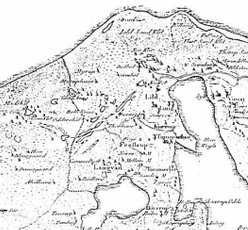
The village of Myrup
Myrup is situated in Vester Han Herred in Northern Jutland close to the little village of Glæde in Lild Parish. Today Myrup only consists of a two-winged farm, Myrupgård (gård = farm), used as a summer cottage, but 340 years ago Myrup was still a little village with several farms and houses.
Myrup as a place name is very old. In a document from 1483 the name Meyrup is mentioned, and in 1552 Myrrup. From 1656 it is known in the current spelling, Myrup.
The first part of the name ‘Myr’ is an old Danish word for ‘mose’ – i.e. ‘bog’, as ’myr’ or ’myre’ means ’mose’, which can be seen as endings in other Danish city names and still as a common word in Swedish. Last part of the name ‘-rup’ means ‘torp’ or ‘bebyggelse’ – i.e. ‘small settlement’. This is a common ending for city names in Denmark. Before the sand drifting began in the 1500s there were many bogs in Vester Han Herred. There are still several water holes left in the area. Therefore, the name Myrup most likely comes from ‘en lille bebyggelse ved mosen / mellem moserne’ – ‘a small settlement at the bog / between the bogs’..
Myrup is along with Nørklit and Bulbjerg mentioned as one of the three villages that had been sanded in 1590. Thy, Vester and Øster Han Herred are those parts of the country that have been most devastated by the sand drifting through time. It culminated in the 1500s and decreased until the end of the 1800s where it was almost gone. In the end of the 1800s and the beginning of the 1900s many initiatives were launched to stop the sand drifting by among other things planting dune plantations, as for example ‘Lild Klitplantage’ (Klitplantage = Dune plantation).
The oldest report on the drifting sand and its havoc in the parishes of Lild, Tømmerby, Vust, Thorup and Klim is from 1543. In 1625 the vicar reports that the three villages (Myrup, Nørklit and Bulbjerg) ”for 32 years no tax or other services has been able to give”, and the parish lay open to the sand drifting which was getting worse every year. They had to shovel the sand away from the houses and farms just to get in and out of the houses, and the fields were covered in a deep layer of sand. The drifting sand made many families homeless and starving, and houses and churches were abandoned or even moved. Around 1800 a third of the fertile land in Thy and Vester Han Herred was destroyed by the drifting sand.
It must have been very harsh to live here and cultivate the sandy fields. Many even chose to earn money by fishing too or go trading with Norway over the sea. It is very likely that the tough life was the reason why the families moved from place to place. The birth place of their children shows how they were moving from one parish to another. In the second half of the 1800s some even chose to leave Vester Han Herred and Denmark and immigrated to America.
Though the village of Myrup slowly disappeared, it still existed in people’s minds and up until 1900 the houses in the area where the former village had been, were called Myrup. From ‘Hannæs Birk Tingbog’ (a legal book with summaries from Hannæs jurisdiction) it is possible to see that the farm Ræhrgård was situated in Myrup as late as in 1652; in the census of 1787 Ræhrgård was in the village Glæde. In the same legal book in 1631 Myrup Klit is mentioned. In the 1750’ies the parish register mentions Øster (East) and Vester (West) Myrup, which probably refers to Myrupgård (-farm) and Myruphus (-house). In the late 1700s Myrup consisted of a farm, Myrupgård, and some houses including Myruphus – the latter situated approximately 500 m south of the farm. During the 1800s the land of Myrupgård was divided into several (Myrup)houses. Since 1942 Myrupgård has been the only house left of the village Myrup.
When was Myrupgård named Myrupgård? Has the farm always been called Myrupgård? Or did it come to be called so because it was the last farm in Myrup village? In the parish registers it only says ‘in Myrup’, but now and then the vicar wrote ‘at Myrupgaard’.
The first time I find the farm mentioned as Myrupgård is in Lild parish register, when Niels Christian Myrup’s widow Karen Pedersdatter died ’at Myrupgaard’ in 1810. And in 1812 when “Niels Nielsen Myrup and wife Mette Mortensdatter at Myrupgaard had a daughter Anne Magrethe”. Their twins, Anne and Elisabeth, were in 1824 also born ‘at Myrupgård’. Their 12 siblings born between 1805 and 1830 were all born ‘in Myrup’.
The next time Myrupgård is mentioned is not until 1858 when Christen Kold Vabesgaard died 3 years old as a son of “farmer Christen Jensen Vabesgaard at Myrupgaard”. The next time is in 1892 when Niels Christian Nielsen (Myrup) died as “Widower and Pensioner at Myrupgaard” and in 1894 when Karoline Christine Myrup was born as daughter of “Kasper Djernæs (Vabesgaard) Farmer at Myrupgaard”. Otherwise it just says ‘in Myrup’. The first census where Myrupgård is mentioned is from 1870. The earlier censuses just said ‘Myrup, en gård’ (a farm). Therefore, there is no way to know when the farm was named Myrupgård.
The parish registers often just mention ’in Myrup’, and it is uncertain whether it is Myrupgård, Myruphus or one of the neighbors they meant. There have been many houses ’in Myrup’, but in the censuses, it is seldom that they have a name, e.g. Myruphus. In the census from 1845 three houses in Myrup are mentioned besides the farm, but with no names. During the period 1823-49 Little Myruphus is also mentioned in the parish registers, in 1840 ’on Myrup’s property’, in 1845 ’on Myrup Field’, in 1847 ’on Myrup Heath’ and in 1870 ’on Myrupgård’s land’.
In the census from 1901 the numbers from the land register are included for the first time. Myrupgård was located on the parcel numbers 88a and 88c and Myruphus on 89. The census commission agent has written ’in Myrup’ at a total of 13 houses. Later this ’in Myrup’ has been crossed and changed to ’Lild Klit’. While two of the houses indeed are on Myrup parcel numbers, the rest of the houses are neighbors to the north and west. It is very likely that, as a tradition from old time, ’Myrup’ included several houses in Lild Klit – besides Myrupgård and Myruphus on the parcels 88+89. And this is probably why it looks like so many people lived in “Myrup” according to the early censuses. And this is why it confused me so much in the beginning.
Today, the only parcels that still exist in the area are the parcels 88a and 88c with Myrupgård. The parcels 88b, 88d and 88e, and 89 (with the now gone Myruphus) has disappeared, ‘absorbed’ in the parcel 9i, sold to the State, and Lild Klitplantage was established as one of the last plantations in 1930 to stop the sand from drifting.
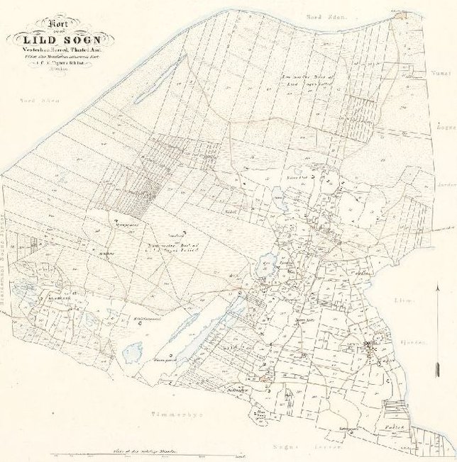
Maps of land register from the beginning of the 1800ies
Download or print the article as PDF
Sources
- T
Landet mod Nordvest, Thy og Vester Hanherred, Red. C. Brunsgaard og Henry E. Pedersen (1946)
Thy - landet mod nordvest (2006)
Censuses and church registers
Last updated 14.03.2018 by Lis Myrup